Layout of all-sky survey sky maps
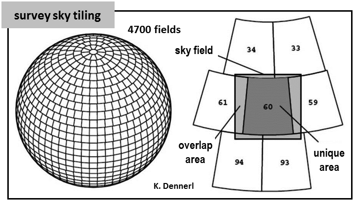
The sky is divided into 4700 non-overlapping, unique areas ("sky tiles"). Each sky tile is defined by a unique lower and upper limit in right ascension and declination coordinates, respectively. Of the 4700 sky tiles, eROSITA-DE has proprietary rights on 2447 of them, of which 199 sky tiles have shared rights between the German and Russian consortium. The FITS table here, contains the boundaries and center coordinates of the 2447 sky tiles.
The size of these sky tiles is exactly three degrees in declination and approximately three degrees in right ascension (on the side facing the equator), resulting in an average area of about 8.78 square degrees. Each unique sky tile is embedded in an overlapping, square sky field or sky map (defined as local parallel tangential projection; north pointing upwards) of size 3.6° × 3.6° centred on the sky tile. The minimum overlap between neighbouring sky maps is between 15 arc minutes for polar maps and 18 arcmin for equatorial maps.
After event calibration, the incoming data stream is split and accumulated in the same number of overlapping 3.6° × 3.6° sky maps. Source detection and further source-level analysis are then performed on these 3.6° × 3.6° sky maps.
Tiling of the sky into equal-area overlapping 3.6 × 3.6 square degrees sky maps.